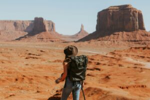

Known as one of the most charming valleys of Nagaland, the Dzukou Valley is a spectacular visual treat of emerald green hills, lush forests, winding streams that freeze in winter, and countless colorful flowers that spill over the valley’s vast creeks and meadows. It is by far the most famous trekking area in Nagaland and after completing the relentless steep climb and subsequent 2-3 hours of walking through low bamboo thickets, one begins to understand why.
The topography indicates that the valley is the floor of a large crater or caldera of a long extinct volcano, and one can look down on it from the caldera’s rim. At 2,400m there is a special kind of beauty, almost deserted, especially in the long shadows of early morning or late afternoon. Above the valley is a huge mountain hut (more of a shed). Behind the hut is a small section of remnant oak and rhododendron woodland, with the occasional Magnolia campbellii. Beyond this are some small, steep hills that tempt one to climb for a better view. Halfway through, any traces of trails disappear and one is fought against endless bamboo bushes. The only other thing you have to do is descend an easy route 150 meters to the caldera, which is so large and open that it resembles a high mountain valley. It is very green, with extensive swamp and water plants and paths lined with primroses.
Read also: Discover the Best of the USA
In the monsoon season, tourist brochures understandably talk about rich flowering meadows and a locally abundant pink lily. Unfortunately, bamboo and anything else that catches fire is burned, so there is little forest around the Dzukou Valley today. There are birds, but they are so conditioned to fear humans that they are rarely seen. Locals are experts with slingshots and guns; indeed, we found one of our porters baking baking pellets over our cooking fire for catapult ammunition, and later discovered a woodpecker, complete with feathers slowly baked in the embers.
At the moment it is a great place for young people, traveling independently, to gain some trekking experience. As foreigners, we were very motivated to see its popularity. It is clear that better maintained access trails, control of fires and hunting are desperately needed. Ideally, there should be a resident resident there all year round. Interpretive information about the geology and natural history of the region would greatly enrich the visitor experience and improve the status of the valley.
DAY ONE
KOHIMA-DZUKOU TRACTORS’ HUT
DISTANCE 9 KM TIME 5 HOURS
LEVEL MODERATE
Start early morning and follow NH39 from Kohima to Zakhama check– Post (15 km by road), marked by a small tea shop. Here a fee of INR 60 is charged for charity – the North Kohima Students Union uses it to maintain and keep the area clean. From the Zakhama check-post, walk along the stream on the 2 km jeep bell road (jeeps not allowed), through bamboo forests and deodar. Where the road ends the path climbs steeply to the left over the stream for 1km. Follow the left bank which then meets a rest area. This is known as the Crying Child Valley like the beautiful tragopan pheasant, with its cry akin to the lamentation of a child, lives in this area. Walk along the right bank of the stream. From here the path is steep and in places you may have to go on all fours. It is 5 km from the rest area to the unnamed 2,550 meter pass, which offers breathtaking panoramic views of the Dzukou Valley.
")
From the vast caldera of the valley floor, which is rich in colorful flowers during the monsoon months, emerge exceptionally gentle foothills and grassy meadows. From the 180 degree view, 160 degrees is the Dzukou Valley alone. From here you are in a dwarf bamboo forest, which looks like tall grass from afar. Over the switchback, the trail slips 650 feet below the ridge before reaching a split. Take the right one, which is a fairly easy short descent. After half an hour you will come across a small stream. Cross it to get to the Hut of Dzukou Trekkers, where the chowkidar can rustle up a good welcome meal. The Dzukou Trekkers Hut is about the size of a small factory or airplane hangar and is welcoming. It has a huge concrete floor with a few wooden platforms serving as beds, where one can lay down sleeping bags for the night. A small separate kitchen, a small but functioning toilet block and a good water supply complete the facilities. Local trekking clubs appear to be frequent visitors to the trekking hut.
REST DAY (OPTIONAL)
Camp in the Trekkers Hut and explore the wide and beautiful Dzukou Valley. In front of the Trekkershut you can take a walk to the Ghost Caves or ‘Bhoot Gufa’ as they are known locally. Remember to carry torches as the cave extends for almost a kilometer. Or simply descend around 30m from the hut to the bottom of the valley’s vast caldera. You can explore the vast grasslands and rolling meadows, bursting with flowers in the monsoon months.
DAY TWO
DZUKOU VALLEY-VISHWEMA VILLAGE
DISTANCE 14 KM TRAIL AND 9 KM ROAD TIME: 6-7 HOURS
LEVEL: EASY MEDIUM
")
Bring a lunch and drink enough water from the Hiker’s Hut for the day, as there is nothing on the route to the pass. Return to the fork in the path and take the right path this time (it would have been left when it came) Zakhama). It’s a fairly flat, easy trail that runs along the left ridges of the valley through dwarf bamboo, which often need to be separated to see the trail in front. After a short series of zigzags you reach a new pass on the ridge from where you take the highway to Imphal and the vast Vishwema Village. This is the point where you leave the Dzukou Valley. At the pass you will come across a water pipeline, the water source for Vishwema Village. Follow it all the way down. The bamboo will be useful as support for the first part of this descent, which is very steep. At the bottom of the hill the path meets a road marked ‘ Trekkers point ‘. From here, unless you have arranged in advance for a vehicle to pick you up, you will walk the 9 kilometer road that meets the NH61 at Vishwema Village. You can spend the night in the communal hall of the village (free), and buy food in the shops.
DAY THREE
VISHWEMA VILLAGE-JAPFU PEAK BASE
DISTANCE 10 KM TIME 4-5 HOURS
LEVEL EASY
Carry water, tents and food supplies from Vishwema. There is no water available until the base of Japfu Peak. From the village, drive northwest on the main road for 3 km. The road turns into a well-defined trail surrounded by lush forests over a 7 kilometer stretch to the base of the peak. The trail gently slides around the ridge, which faces you, making it a gradual and easy climb. There are plans to build a hut, but there are no visible signs of this yet. The forests here are full of rhododendrons of different shades. A small forest clearing and freshwater spring provide a good campsite at the base, marked by a ‘Japfu Peak’ sign.
DAY FOUR
JAPFU BASE CAMP-JAPFU PEAK
DISTANCE 5-6 KM TIME 4 HOURS
LEVEL GUGH
")
Ideal from camp at 2am to get a beautiful view of the sunrise from the top, which is actually the highest point on the ridge. The path is well defined all the way to the top. Initially through a dense forest with little view, the climb is steep. The final 500-foot section of the trail rises above treeline and ascends smoothly to the summit. From the Japfu peak (3,050 m) you can see a huge amount of valleys, hills and villages. Half of Nagaland is visible from here, besides villages on the Arunachal Pradesh side and Dibrugarh in neighboring Assam. Get back on the path, return to Vishwema Village and head to Kohima.
Read also: