
What to see in Peru – Complete guide of the main places to visit in Peru
Peru is the third largest country in South America by surface area and owes its geographical position to an incredible variety of climates, landscapes and situations. Erroneously, although deservedly, it is often associated mainly with Macchu Picchu , the mecca of adventure tourism, yet when asked what to see in Peru I could talk for hours, and in fact I do.
Peru has much more to offer:
- a coastal desert as rich in history as it is in marine fauna, overlooking one of the deepest ocean trenches in the world;
- mountains with very high peaks that guard 80% of the world’s tropical glaciers, home to ancestral animals such as llamas and condors;
- the Amazon forest , habitat of an infinite number of animal and plant species, largely mysterious and unexplored, an inexhaustible source of surprises and adventures, but also of dangers and exciting emotions.
- dozens of different cultures and traditions , from the current descendants of the Incas to the Amazonian populations who still live in full contact with nature in the Amazon Forest.
The fascinating Peruvian destinations are many and very different from each other, so as to allow an incredible range of options: from cosmopolitan Lima to the more rustic Titicaca , from the coastal desert to the incredible Amazonian nature. 4 weeks are not enough to fill up on Peru.
Don’t know where and how to start this journey? I have created this guide for you in which you will discover what to see in Peru and the 10 places not to be missed!

Five
Upon my arrival in Lima I was enthusiastic and curious, like the many travelers who approach the South American continent for the first time. I didn’t have the faintest idea what awaited me. Lima is the largest city in the world built on the desert , a humid desert where it never rains for 10 months of the year (March-December).
The sun rarely comes out and the sky is covered by a gray veil that gives a melancholic air to the urban landscape.
In the months of July and August the humidity is so high that it can reach 100%. Conversely, in the summer months (January-March) the sun beats down hard and you can’t see a single cloud in the sky.
Lima is divided into dozens of neighborhoods, some small and colonial while others, born due to massive Andean immigration , have more than a million inhabitants. The “visitable” and most touristy ones are the Historic Center , Miraflores and Barranco .
To get a first overview of Lima I recommend you book the free walking tour of Lima or, if you prefer an Italian speaking guide, the 3 hour tour with an Italian guide.
Historic center of Lima
In the Historic Center , also called Cercado, the Spanish colonial past is strongly present and characterizes all the buildings that overlook the main squares, dedicated to the heroes of the fight for Peruvian independence from the Spanish crown, which took place in 1821.
Plaza de Armas is the heart of old Lima, seat of civil and religious power, while the adjacent Plaza San Martìn is the nightlife hub in the center of Lima. At night some darker and more degraded streets should be avoided to avoid unpleasant encounters.
Miraflores
An old taxi driver from Lima once told me that Miraflores, fifty years ago, was one of the few green places in Lima, where trees and palms overlooked the Pacific Ocean.
In recent years Miraflores has transformed so much that it is currently the most modern and commercial district in the city.
All the most expensive shops, luxury hotels , banks and multinational companies are located here. Miraflores is perhaps the only neighborhood in Lima with cycle paths, clean and swept by teams of garbage collectors and where since 2015 traffic has been banned for the thousands of combi 1s that speed dangerously across Lima.
In Miraflores it is possible to do your shopping in supermarkets like Wong or Vivanda where you can find almost everything, and when I say everything I also mean Italian, Belgian or Japanese products.
Obviously the prices in the bars, supermarkets, restaurants and shops of Miraflores are the highest in all of Peru.
In the center of Miraflores there is Parque Kennedy , a triangle-shaped park where a colony of cats lives, cuddled by numerous tourists.
Following Calle Larco you arrive at the Malecòn where you can observe the Ocean from above.
A little further on, on the right looking at the Ocean, there is a beautiful little park called Parque del Amor where numerous love poems follow one another and the benches vaguely recall the mosaics of Parc Güell in Barcelona.
Ravine
Barranco is the smallest neighborhood in Lima and the one that more than any other has managed to preserve the original nineteenth-century architecture.
Even today, Barranco resists the building boom, keeping the colonial houses and the bohemian air that you breathe while walking through its Plaza de Armas and the surrounding streets almost intact. In recent years it has become the liveliest and youngest cultural center in the capital. Many artists and numerous foreigners live in Barranco , giving the neighborhood a European feel.
Barranco in Castellano means ravine . The neighborhood was named so because of the green cliffs overlooking the ocean.
Walking on the Malecón you will come across a wooden bridge called the ” Bridge of Sighs ” which has nothing to do with the most famous Venetian bridge. Near the bridge you will find many nice bars and restaurants to go to for dinner.
On one side of the square stands El Juanito , an ancient bar where it is possible to taste liqueurs and sanguches (sandwiches) according to Peruvian traditions. For vegetarians I recommend the Cafe Expreso Virgen de Guadalupe , a restaurant inside an old carriage of the train that connected Barranco to Miraflores, now located a few steps from the square, where you can taste all the traditional Peruvian dishes such as causa or la palta rellena , revisited in a veg version.
I do not recommend visiting the huge urban suburbs to travelers arriving in Lima, unless you are accompanied by people who live or work there. Over the last thirty years, due to Maoist terrorism and the civil war that broke out in the Andes, millions of people have emigrated to Lima, occupying the stone and sand hills called cerros .
Millions of people live here in conditions of poverty , without services, sewerage or drinking water. To understand and see this reality, in a safe context, it is possible to take a ride on the electric train that connects the center with the southern suburbs and allows you to see the city from above.
Lima has its own climate so from March to December the sun hardly comes out.
While January and February are summer, July and August are the coldest and most humid months in the capital.
COMBI
Combis are the most common means of transport in Lima. They are divided into minivans where it is not possible to stand upright and cousters, which are slightly larger, we can call them minibuses. They are all vehicles of different private transport companies that compete to transport millions of Limeños

Paracas, Ica eHuacachina
A few hours by bus from Lima, heading south, is Paracas , a quiet and pretty fishing village. For a few years Paracas has become the starting point for visits to the national reserve , reachable by bicycle or quod. The reserve is nothing more than an enormous desert of stones and sand, with very high cliffs overlooking the Pacific Ocean which only has the name pacific.
The very long beaches of an intense ocher color are the habitat of numerous species of marine animals . The excursion to the Ballestas Islands , by fast motorboat, offers the opportunity to see up close the colonies of penguins, sea lions and cormorants that inhabit the islands. On the road to Ica it is possible to observe the candelabra , a huge 50 meter geoglyph created by the Paracas culture, in relation to the more famous Nazca culture.
The Nazca lines can be observed on board a small plane which will make numerous ups and downs in 15 minutes at a cost of around $100 and which you can book here .
An hour from Paracas stands the city of Ica , the wine capital of Peru since colonial times. Ica has remained isolated from Lima and the coast for many centuries due to the high sand dunes that surround it.
The Huacachina Oasis is one of the most visited places in the city. Here it is possible to go sand-boarding and whiz down the dunes on board the dune buggies. From the top of the dunes it is possible to observe the panorama reminiscent of the Sahara and enjoy spectacular sunsets and starry views.
In Paracas and Ica the sun shines all year round. December/February the warmest months
Recommended tours from Paracas, Ica and Huacachina
In each of these destinations you can take beautiful tours, among the main ones I recommend you book the following:

Arequipa and the Colca Canyon
The road that separates Ica from Arequipa is desert, often overlooking the ocean and long, so much so that it takes 12 hours by bus to travel it.
In Peru it is possible to cover these distances at night on comfortable buses with sleeping seats that we dream of in Europe.
Arequipa, also called the Ciudad Blanca because of its white buildings built with white sillar (an indestructible volcanic pumice), is the second largest city in Peru by population and size .
It is located at 2,363m above sea level and has a dry climate all year round, apart from the months of January and February when the city benefits from the effects of the Andean rainy season.
A peculiarity of its skyline is the enormous Misti volcano which dominates the city with its 5,821m.
The origins of its name are not clear: the Aymara , the populations of the plateau who inhabited Titicaca, called it Ari quepa , or behind the mountain, while another legend tells that the Inca emperor said, in response to the requests of his followers to stay in this beautiful valley bathed by the Chili river, “ Ari qhipay” , in Quechua “stop here” .
Attractions of the city are the market, the Convent of Santa Catalina and the Juanita Mummy Museum . A few hours by bus from the city there is an incredible spectacle of nature: the Colca Canyon .
Twice as deep as the Grand Canyon in the United States, with its 4,100m difference in altitude, Colca is a spectacle for the eyes and the heart.
To get there you will pass passes up to 5,000m high and characteristic Andean villages such as Maca, Yanque, Chivay and Coporaque where women still wear traditional typical clothes.
Remember that you will be at around 4,000 metres, and it may give some people headaches and nausea (so-called soroche ) but nothing that a good coca mate can remedy.
Cruz del Condor is a mirador, a panoramic point from which every early morning you can see the flight of condors gliding into the canyon in search of food.
The condor is an endangered species ; being able to admire this enormous and sacred animal in all its grandeur is a priceless spectacle. In the surroundings of Colca they identified the source from which the Ucayali originates which then turns into the Amazon River.
BEST TIME TO GO
The rainy season runs from December to March while from May to September temperatures drop below zero at night.
Recommended tours from Arequipa
From Arequipa you can take several very interesting tours and these are the ones I recommend you evaluate:
MATE DE COCA
Hot drink widespread throughout Peru, used for millennia in the Andes for its beneficial properties. Coca is a sacred plant for the Incas and is still used in infusions and preparations. It has no physical or psychological altering effect and is used as a digestive and to alleviate nausea and headaches due to height. Chewing and ingesting many leaves throughout the day can lead to not feeling hungry, tired and lacking oxygen.
ROCOTO RELLENO
The rocoto is one of the hottest chili peppers in the world. The size of a tomato, it is stuffed and cooked in the oven. It is a typical dish of the Arequipa region.

Lake Titicaca and its islands
Located at 3,812m above sea level, 193km long, 64km wide and almost 300m deep, Lake Titicaca covers a surface area equal to 22 times that of Lake Garda and is the highest navigable lake in the world.
Titicaca can be considered the ancient heart of Andean cultures . In fact, ancient legends say that Viracocha, the creator god of the World, was born from its waters. The Aymara culture spread and prospered until the expansion of the Incas who conquered the shores of the lake around 1200 AD.
The lake has around forty islands , the most famous of which are Amantaní and Taquile , on the Peruvian side, and Titicaca and Coati, better known as Isla del Sol and Luna, on the Bolivian side. In all the islands it is possible to observe the remains of ancient civilizations, where there is often a circular temple dedicated to Pachamama , Mother Earth.
In most of these islands the main activity is fishing and the cultivation of quinoa and potatoes.
In recent years, community tourism has been gaining ground , where travelers are hosted by local families. They are wonderful sharing experiences.
From Puno , the Peruvian city overlooking the lake, it is possible to visit the floating islands of the Urus , an ancient population that has no genetic or cultural relationship with the Incas and Aymara. This full day tour will allow you to visit the islands of Uros and Taquile
Even today their origin remains a mystery. The Urus live on floating islands built from reeds harvested from the lake. The rush, called Totora, is fundamental in the life of the Urus for food and the construction of houses and boats with which they travel.
BEST TIME TO GO
The rainy season in the Andes runs from December to March. The rest of the year is considered dry, therefore better for travelling, although cold

Cusco, the Sacred Valley and Machu Picchu
According to many, Cusco represents the center of the world. The city is located in a green valley at a height of 3,400 meters above sea level and can be reached by plane from Lima, or by bus from Arequipa and Puno.
Cuzco is the first tourist center in Peru as climbing Machu Picchu is the dream of many travellers.
Cusco was for some centuries the capital of the ancient Inca empire , as large as the one founded by the Romans.
Pizarro entered Cuzco in 1533 and found the capital still smoking from the fires and destruction caused by Atahualpa’s soldiers during the fratricidal war that divided Peru just a few months before the arrival of the conquistadors.
The wooden and straw roofs had disappeared from the houses; however, the formidable and indestructible bases of enormous connected stones remained intact. On these the Spaniards built churches and palaces , incorporating entire blocks of buildings and raising walls of adobe (mud and straw), covered with white plaster.
In the severe Inca geometry they inserted balconies , sculpted portals, bas-reliefs and railings. This Mediterranean wave created imaginative and poetic effects in the city that are still present today.
In the city it is possible to visit the Plaza de Armas and its Cathedral , the Templo del Sol and the San Pedro Market .
Just outside the city are the Inca complexes of Qenqo, Tambomachay, Puca Pucara and the impressive fortress of Sacsayhuaman , built strategically on a hill overlooking Cusco (it is still not known how the Incas built this fortress, moving boulders 20, 80, up to 200 tons perfectly smoothed to fit together).
BEST TIME
In the Andes the rainy season runs from December to March. The rest of the year is considered dry, therefore better for travelling, although cold
To find out what to see in Cusco I recommend you read this post. If you want to know how to reach Machu Picchu and find 10 different ways I recommend reading the complete guide to Machu Picchu.

Sacred Valley of the Incas
The Sacred Valley of the Incas , also called the Sacred Valley , is home to Maras, Moray, and Chinchero . The famous Maras salt pans are natural basins dug into the mountainside, used since ancient times to extract the precious salt. Moray, which at first glance may seem like a huge amphitheatre, is instead an ancient agricultural laboratory where the Incas grew corn and potatoes in concentric terraces.
Chincero is a small, picturesque village at the bottom of the valley, famous for its craft market and for the ancient legend that tells of the birth of the rainbow in the surrounding mountains.
The visit to the Sacred Valley ends in Ollantaytambo where it is possible to visit the ancient fortress and the temples of the Sun and the Moon.
These sites can be visited in a day with tours departing from Cusco, such as this one .
From this town you take the magical Inca Train , the only working train in Peru which, crossing the entire valley with the Urubamba river at its side, will take you to Aguas Calientes , the last characteristic village at the foot of Machu Picchu.
The train costs around $100 and takes about two hours. The economical alternative is to take a collective from Cusco early in the morning that will take you to Hidroelectrica after 7 hours of hairpin bends and ravines. From here you will have to walk about 3 hours along the train tracks to reach Aguas Calientes. Typically you opt for this tour which costs the same as you would pay if you organized it yourself and also includes the ticket to Machu Picchu and the obligatory guide.

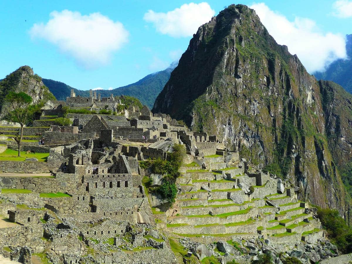
Machu Picchu
Machu Picchu is the jewel of Inca architecture. To build this city on the crest of the mountain, the Inca engineers had to overcome many limitations and problems due to heavy torrential rains and the lack of space in which to build.
To climb Machu Picchu there are two alternatives. The first is to get on a bus which will take you to the park entrance in half an hour.
The second involves walking the ancient Inca path which from the river allows you to climb the mountain and reach Machu Picchu in just over an hour .
In both cases, the sooner you move, the better you will avoid the queues of tourists who crowd Machu Picchu starting from 11am. The best thing is still waking up in the dark and enjoying the sunrise at the top.
According to many, Machu Picchu is a magical place where various powerful energies meet. Personally, I was struck by the fact that both of my cell phones stopped working, the smaller one forever, while my more modern smartphone only came back to life after 3 days.
Also read 10 ways to reach and visit Machu Picchu
The Amazon rainforest – Iquitos
Iquitos is the capital of Loreto, the largest region of the Peruvian Amazon .
It was founded in 1757 by the first Spanish missionaries who reached these remote areas in the north-east of the country.
To date, the city has no land road connections, remaining isolated from the rest of the world; it is possible to reach it only by air from Lima or by boat along two large rivers, the Ucayali and the Marañon , which join a few km before the city to form the Amazon River .
The isolation to which this city has been subjected over the centuries has allowed the preservation of the cultural identities of the indigenous pueblos , the original inhabitants of these lands. In fact, there are many communities that still live along the peaceful Amazonian rivers, even several days’ sail from Iquitos.
The Peruvian state has always considered these native communities as destitute, as they have never needed money or titles to live in dignity and in full contact with nature.
Iquitos experienced a boom at the beginning of the 20th century where, during the rubber fever , Portuguese and English entrepreneurs amassed a fortune by enslaving the indigenous populations in the collection of rubber used in the then recent production of tyres. All the colonial buildings that adorn the center of Iquitos are from that era, with their facades covered in Portuguese mosaics.
The city is incredible. Due to isolation, almost all things arrive by plane or boat. Also for this reason you hardly see any cars in the city but thousands of motorbikes and motorbike taxis.
BEST TIME
Dry season (summer) runs from July to December, rainy season (winter) runs from January to June. the ideal period is the dry one

A 10-minute motorbike taxi ride from the center we find the most picturesque and magical neighborhood of Iquitos: the ” Barrio de Belén “ .
The neighborhood was born on the banks of the Rio Itaya and is divided into two parts: the upper one which houses its enormous market, the beating and commercial heart of the city; the lower one, called Pueblo Libre de Belén , is the most densely populated and marginal area of the city.
T he Rio Itaya suffers from the flooding of the Amazon River. In the months from March to June the lower part of this neighborhood floods with several meters of muddy water, transforming the lives of the inhabitants of Bélen.
The ground floors of the houses are emptied and people live on the first floors. Kilometers of wooden walkways , a few meters high, are built throughout the neighborhood so you can walk without getting your feet wet in the dirty brown waters (the neighborhood has no sewers and during the flood months the garbage is not collected).
The Belèn Market
Here thousands of people sell and buy the numerous products of the Amazon region. Open from 5am to 1pm, the market is a huge labyrinth with a thousand alleys full of stalls and informal shops teeming with people.
Oranges, bananas, yucca, spices, fish and meats of all kinds. Over the last hundred years the Belén market has changed little and remains the quintessential shopping place in Iquitos.
On its stalls, open every day from Monday to Sunday, you can buy fish freshly caught in the rivers and still alive, smoked meats hunted by the Indians in the forest, fruit and vegetables from the Amazon region, but also household items, cell phone accessories and clothing. Salespeople shout, customers haggle, everyone is looking for the deal .
The Amazon , not only by definition, is the green lung of the world, contributing essentially to the possibilities of survival on our planet. The forest surrounding Iquitos is very rich in biodiversity .
The Allpahuayo Mishana National Reserve is an incredible reserve that begins just 20km from the city of Iquitos. In the surroundings of Iquitos it is possible to visit numerous communities that still live in contact with nature, where consumerism seems not to have succeeded in transforming millennia of habits and traditions.
Over the millennia, the treatment of illnesses was (and still is) entrusted to curanderos who, through an incredible knowledge of the surrounding nature, manage to cure using the 800 sacred plants ( plantas maestras ) present in the Amazon. An ancestral tradition is the shamanic one which increasingly attracts tourists and travelers eager for experiences that go beyond the senses and normal perceptions.
The Amazon rainforest – Puerto Maldonado
Puerto Maldonado is the capital of the Madre de Dios region , in southeastern Peru. For some years, thanks to the Carretera Interoceànica which connects Cusco with the Brazilian border, it has been possible to reach Puerto Maldonado by bus by land (approximately 40h from Lima, 8 from Cusco) or more comfortably by plane (1.5h from Lima, 45min from Cusco) .
This region is home to the most virgin and impenetrable parks and reserves on the planet, whose meanders are inhabited by communities uncontacted by civilization who have lived in the forest in the same way for thousands of years.
The region holds the world record for the number of amphibian and reptile species.
Madre de Dios has an incredible biodiversity due to the different ” ecological fields ” that alternate from the 3,000m high Andes of Cuzco to the extensive low forest.
This part of the Amazon is the habitat of an enormous quantity of colorful birds, enormous cats such as the jaguar, the tigrillo and the puma, as well as reptiles and snakes such as the boa constrictor and other more deadly ones. There are also numerous species of monkeys and fish that populate the rivers. There are 900 species of butterflies present in the region.
Madre de Dios offers the opportunity to visit two incredible protected areas: the Parque del Manu and the Riserva de Tambopat a. The tourist activities are increasingly varied, such as canoeing at night or canopy (rope descent “flying” between the treetops).

Ancash – The White Mountain Range
The Ancash region is a paradise for trekking lovers .
Contiguous to that of Lima, in a northerly direction, it is also called Peruvian Switzerland, certainly not for the money contained in the bank vaults but for the views that recall Alpine landscapes.
Its capital is Huaraz , from where all tours depart to discover the beauties of this region.
Anchas enjoys 20 peaks that exceed 6,000m in height, divided between the Huayhuash cordillera and the Blanca cordillera .
This region is home to 70% of the world’s tropical glaciers .
Unfortunately, due to the greenhouse effect, these splendid ice giants are disappearing.
In the last 30 years they have reduced by 40% and the rate is growing so the white mantle of the peaks could disappear in the next few years.
The highest mountain in Peru is Huascarán which with its 6,768 meters is the highest peak in all the tropical areas of the world. From the city of Huaraz (3,052m) it is possible to observe the impressive massif in all its grandeur.
There are treks of all types, one day for beginners like me, or entire weeks for truly expert mountaineers (or mountaineers?).
Personally I visited the Pastoruri glacier , beautiful and easy to reach, and the wonderful Lagoon 69.
Reaching the latter was the hardest walk of my life, 13km of ups and downs in 7 hours of trekking.
BEST TIME
Dry season (summer) runs from April to December, rainy season (winter) runs from December to March. The ideal period corresponds to the dry season.

The north coast of Peru
Over 1,300km of asphalt lead from Lima to the customs with Ecuador; 1,300km quite monotonous, where the silence of the desert is interrupted at times by the roar of the Pacific waves .
Since they awarded the world record for the longest wave to Chicama, this small fishing town along the Panamerican North has been transformed, seeing a growth in the interest of surfers who come from all over the world to surf the almost 4km of continuous wave.
A characteristic village worth visiting is Huanchaco , famous for its totora horses , rudimentary single-seater boats dating back to the Chimu era, with which fishermen challenged the powerful waves of the ocean until not long ago.
The most famous seaside resort, flocked by foreign tourists in the summer months, is M Ancora , on the far Peruvian coast, a few km from the border with Ecuador.
The largest city on the north coast is Trujillo , famous for the marinera dance and for being the site of important legal treaties. At the same time it suffers from a bad reputation which describes it as a dangerous city, having given birth to numerous hitmen.
The Chimù culture
The northern coast of Peru has been inhabited since ancient times: from the 1st century BC the Moche culture expanded in these places and was supplanted, starting from the 12th century, by the Chimú culture , before the Inca conquest and the subsequent Spanish occupation .
The Chimú had transformed the desert into a green valley and built “ Chan Chan ”, the largest adobe (mud and straw) city in the Americas . In 1300 AD, at the moment of maximum splendor, the city had a population of around 100,000 inhabitants and a surface area of 20km 2 . After the Spanish conquest in 1500, the city was heavily damaged due to the belief that gold and silver treasures were hidden in its high and thick walls.
The city’s bas-reliefs highlight the importance of the sea , the waves and the fish. In the ceramic vases brought to light in the huacas (sanctuaries) there are drawings of fruits, animals, mythological subjects, scenes of daily life, wars, horribly mutilated people and sexual perversions.
Two enormous pyramids are dedicated to the Sun and the Moon , buried for centuries by the sand, they are only seeing the light again in recent years. The Huaca del Sol , 48 meters high and 135 meters wide, used by the Chimú as a military centre, is heavily damaged, while the Huaca della Luna was the religious center of the Chimú culture and it is possible to visit it in all its grandeur.

Cajarmarca and Chachapollas
Cajamarca (2750 masl) was founded by the Incas and served as a connection between the southern capital, Cusco, and the northern one, Quito. Today it is the main city of northern Peru .
Cajamarca is famous for its carnival and cheese production . It has gone down in history as the city where the Inca emperor Atahualpa was captured in 1532 by the Spaniards who set a trap for him. The emperor was locked up for 8 months in a room, which can still be visited, where it is said that Atahualpa, after having drawn a red line on the wall with his arm stretched upwards, had sworn, in exchange for his liberation, to fill the room of gold , so dear to the Spaniards.
Indians began to arrive from all over the empire loaded with jewels and gold masks but just when the room was almost full Pizarro’s conquistadors judged the emperor worthy of a death sentence. This event constitutes the end of the Inca empire and the beginning of Spanish rule in Peru.
The lands of Cajamarca have always been exploited to extract the gold stored in its mountains . More than half of Peru’s gold production is extracted from the Yanacocha mine , the largest in all of Latin America. Unfortunately, gold extraction is intrinsically connected with groundwater pollution due to heavy metals such as mercury, used to separate gold from stones.
In the surroundings of Cajamarca it is possible to visit truly spectacular places such as the Bosque de Piedras . Remaining cut off from the main tourist routes that favor southern Peru, Cajamarca has remained faithful to its Andean soul .
Descending the Andes in an eastward direction you arrive at the city of Chachapoyas , the capital of the nearby Amazonas region .
The term chachapoyas comes from an ancient language and means “cloud men” , due to the fact that the part of the Andes that goes from 3,000 to 2,000 meters high is covered by a perennial layer of humidity condensed into clouds. In this part of the forest, called ” selva alta ” or “ceja de selva”, there is already an increase in temperatures and humidity compared to Cajamarca.
In the surroundings of Chachapoyas it is possible to visit Kuelap , the Machu Picchu of the north, a huge pre-Inca fortress built on the top of a mountain at 3,000m high. Almost 600 meters long, the fortress is surrounded by walls 19 meters high in some places. The entire base on which this citadel was built is a huge artificial platform. It is estimated that more tons of stone were moved to build Kuelap than to build the Egyptian pyramids
Daily tours to the Gocta waterfall also depart from Chachapoyas , like this one here , which with its 540 meters of free fall and 771 in total is the highest waterfall in Peru and the fifth highest in the world.
Gocta was only measured in 2006 by an expedition of German geologists.
Before then it was not even considered by tourism, something which, in recent years, has revolutionized the life of the villages of Coca and Cocachimba.
The virgin woods surrounding the waterfall are the habitat of numerous species of plants and animals such as the cock of the rocks and the spectacled bear.
14 Highly Rated Tourist Attractions in Peru
Discover Peru’s Hidden Treasures: From Machu Picchu to the Amazon


